


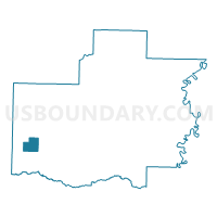
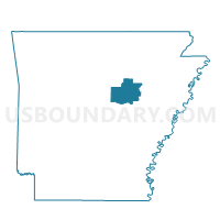
Cleveland Voting District, White County, Arkansas
About
Outline

Summary
| Unique Area Identifier | 528472 |
| Name | Cleveland Voting District |
| County | White County |
| State | Arkansas |
| Area (square miles) | 8.55 |
| Land Area (square miles) | 8.55 |
| Water Area (square miles) | 0.00 |
| % of Land Area | 100.00 |
| % of Water Area | 0.00 |
| Latitude of the Internal Point | 35.16111470 |
| Longtitude of the Internal Point | -92.04031210 |
Maps

Graphs
Select a template below for downloading or customizing gragh for Cleveland Voting District, White County, Arkansas


Neighbors
Neighoring Voting District (by Name) Neighboring Voting District on the Map
- Coffey Voting District, White County, AR
- El Paso Voting District, White County, AR
- Jefferson Voting District, White County, AR
- Royal Voting District, White County, AR
Top 10 Neighboring County Subdivision (by Population) Neighboring County Subdivision on the Map
- Coffey township, White County, AR (1,196)
- Marshall township, White County, AR (910)
- Royal township, White County, AR (703)
- El Paso township, White County, AR (691)
- Jefferson township, White County, AR (507)
- Cleveland township, White County, AR (117)